EgoNav: Bridging Learned Waypoints and Geometry-Aware Local Control for Robust Indoor Navigation
Abstract
Image-goal navigation using lightweight topological maps is a practical paradigm for indoor robot deployment: the map requires only geotagged images, and localization relies on visual matching rather than precise pose estimation. However, learned waypoint predictors can produce targets that violate geometric constraints or deviate from the global path. Executing these waypoints safely further requires a local planner capable of collision avoidance, yet existing systems either lack one or rely on fixed parameters that cannot adapt to confined spaces. To address these limitations while retaining the navigational intuition of the learned predictor, we present EgoNav, a hierarchical system that implements this idea by generating candidates from semantically segmented traversable regions and scoring them alongside the learned waypoint for geometric safety, directional coherence, and fidelity to the learned prior. An adaptive local path planner then executes the refined waypoint with parameters modulated based on the refinement outcome. Experiments in Habitat-sim and on a physical humanoid robot show that EgoNav consistently outperforms contemporary baselines in both success rate and path efficiency.
Index Terms:
Planning, Embodied AI, Embodied NavigationI Introduction
Robust indoor navigation requires both global path awareness and reliable local control. Existing systems that rely on precise metric maps and accurate global localization remain fragile under localization drift and environmental change [1, 2]. Mapless alternatives avoid this dependency but introduce other limitations. Object-Goal Navigation [3, 4] resorts to inefficient exploration over longer distances, while Vision-Language Navigation [5, 6] further requires detailed step-by-step instructions that are impractical to obtain at scale. A practical navigation system should provide global path awareness without requiring precise metric infrastructure.
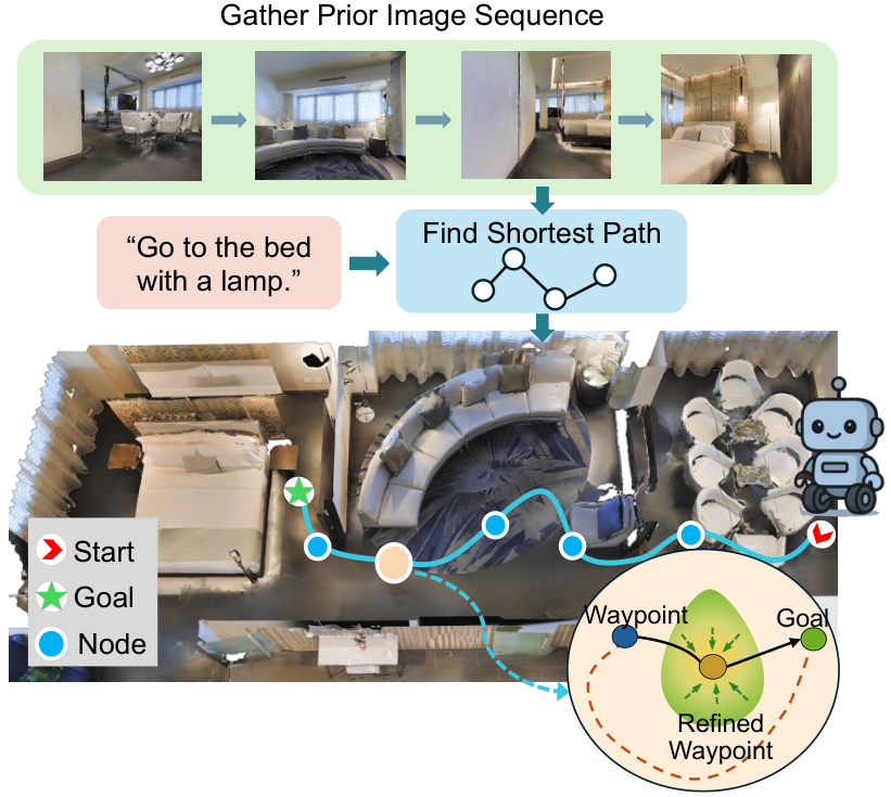
Image-goal navigation using lightweight topological maps addresses the localization dependency directly. The map consists solely of geotagged images collected along traversable paths, making construction, modification, and extension straightforward. Localization reduces to matching the current egocentric view against stored reference images, depending on relative visual similarity rather than absolute pose accuracy. Unlike object-goal and vision-language navigation, it avoids inefficient mapless exploration and the need for detailed step-by-step instructions. Recent learned waypoint predictors such as GNM [7] and ViNT [8], trained on large-scale diverse datasets, can generate ego-centric navigation targets directly from visual observations, enabling deployment across different robot platforms in different environments.
However, deploying these models in real-world cluttered environments exposes two practical limitations. Learned waypoints are derived purely from image-level features and carry no explicit geometric guarantees: they can fall on obstacles, violate traversability constraints, or deviate from the intended global direction. Meanwhile, translating these waypoints into safe robot motion requires a reactive local planner, yet most image-goal navigation systems either lack such a planner or rely on fixed-parameter controllers that cannot adapt to confined spaces. Rather than discarding the learned prediction in favor of purely geometric planning, we leverage local depth and semantic information from the onboard RGB-D sensor to validate and correct it. This motivates a refinement mechanism that preserves the learned prior while correcting its geometric deficiencies, paired with a local planner that adapts its behavior to the surrounding geometry. To this end, we introduce EgoNav, a hierarchical navigation system that bridges learned visual guidance with geometry-aware local control. Built on a lightweight topological map, it refines learned waypoints and executes them with an adaptive local planner. The overall workflow is illustrated in Fig. 1.
Our contribution is at the system level: we integrate established components through a decision-layer coupling absent from prior image-goal navigation pipelines. Specifically:
- 1.
We present EgoNav, a hierarchical navigation system in which learned waypoint prediction, geometry-informed refinement, and adaptive local planning are coupled through an explicit information flow, where refinement outcomes directly modulate the local planner.
- 2.
We design a geometry-informed waypoint refinement module that samples candidate waypoints from traversable regions and selects reliable targets through multi-criteria energy scoring, considering geometric safety, global-direction coherence, and fidelity to the learned prior.
- 3.
We validate the proposed system through extensive experiments in simulation and on a real humanoid robot, demonstrating consistent improvements in navigation success rate and path efficiency over contemporary baselines, with progressive ablations quantifying each module’s contribution.
II Related Work
This section reviews the prior work most relevant to EgoNav, covering visual goal-driven navigation and local path planning, to contextualize our contributions.
II-A Visual Goal-Driven Navigation
Visual navigation research explores various ways to specify goals, each presenting unique challenges and prompting distinct methodologies.
Image-Goal Navigation (ImageNav). In this task, agents navigate to a location specified by a target image [9, 8, 7]. Some methods construct explicit environment representations online: ViKiNG [10] incrementally builds topological graphs with heuristic search, while DeepExplorer [11] learns metric-free topological maps in feature space. GNM [7] achieves broad cross-platform generalization by training on large-scale datasets from diverse robot platforms, and ViNT [8] extends it with a Transformer-based architecture for improved generalization. Unlike these methods, which select subgoal images at fixed intervals, PlaceNav [12] uses visual place recognition (VPR) to retrieve the most relevant subgoal image from a prior map. However, these pipelines execute the predicted waypoints as-is: the outputs of [7, 8, 12] carry no geometric validation, and no mechanism corrects them against local traversability. EgoNav adopts the same VPR-based retrieval as PlaceNav but adds a geometry-informed refinement layer on top of this pipeline (Section III-C).
Object-Goal Navigation (ObjectNav). ObjectNav specifies the goal as an object category, requiring exploration and semantic understanding [13, 4]. Modular approaches guide exploration with learned potential functions [3], online semantic maps [14], or vision-language frontier values [15]. Without a prior map, however, the task often degenerates into inefficient exploration, especially over long distances.
Vision-Language Navigation (VLN). VLN agents follow natural language instructions, demanding cross-modal spatial grounding [16]. Recent LLM-based methods improve reasoning, memory, and safety [5, 17, 18], or adopt modular and hierarchical designs for long-horizon tasks [19, 20]. Yet the dependency on detailed step-by-step instructions remains impractical to satisfy at scale.
II-B Local Path Planning
Local path planning generates feasible short-term trajectories toward immediate goals while reacting to sensor data. Existing strategies span a broad spectrum: reactive methods [21] guarantee completeness through boundary following but often produce suboptimal paths, sampling-based approaches such as Falco [22] achieve high speed by evaluating pre-computed motion primitives, optimization-based techniques including egoTEB [23] refine trajectories toward local optimality at higher computational cost, and path deformation methods [24] adapt a reference path smoothly around obstacles. In settings where accurate 3D maps and precise localization are available, trajectory optimization methods such as Ego-Planner [2] and SVSDF [25] can generate globally informed collision-free paths, but these prerequisites are hard to obtain in real practice. EgoNav builds upon Falco for its real-time efficiency and operates without a metric map; unlike prior systems that run the local planner with fixed parameters decoupled from upstream prediction, it modulates planner behavior based on the refinement outcomes (Section III-D).

III Methodology
III-A Problem Formulation
We consider a robot equipped with an RGB-D sensor navigating in an indoor environment using a pre-collected topological map , where each node stores a reference image and its pose . Edges connect temporally adjacent nodes recorded along the traversed collection trajectory, which guarantees that connected nodes are mutually reachable. When a location is revisited, coincident nodes are merged into one node that retains both views, joining separate segments into a connected graph rather than a single path. Given a target image , the robot must reach the corresponding location by generating real-time, collision-free velocity commands from its RGB observation and depth image at each timestep .
EgoNav adopts a hierarchical strategy that decomposes this task into three stages (Fig. 2). A subgoal retrieval module localizes the robot within the topological map via VPR and selects an appropriate subgoal along the planned path (§III-B). A pre-trained waypoint prediction network then produces an initial waypoint toward the subgoal, and a multi-criteria refinement module evaluates this prediction alongside geometrically grounded alternatives to enforce safety and directional consistency (§III-C). An adaptive local path planner finally generates a collision-free trajectory whose parameters are calibrated to both environmental geometry and upstream correction outcomes (§III-D).
III-B Map-Guided Waypoint Prediction
Active Subgoal Retrieval
GNM [7] is a pre-trained network that predicts an ego-centric waypoint from a current observation paired with a subgoal image, encoding useful priors such as center-biased and smooth motion. In its original formulation, however, GNM retrieves subgoal images sequentially from the recorded trajectory, implicitly assuming the robot tracks the recorded route at a uniform pace, and misaligns once the robot deviates or changes speed. We adopt active subgoal retrieval similar to PlaceNav [12]. At startup, the robot localizes within using sequence-based VPR [26] with MixVPR [27] as the feature backbone, and computes the shortest topological path via Dijkstra’s algorithm. Since nodes are equally spaced at fixed interval, all edges share equal weight, so Dijkstra’s shortest path yields the shortest traversable route. During navigation, is continuously matched against nodes within a sliding window along , producing a matched index ; the node a fixed number of steps ahead is selected as the subgoal and paired with as GNM input, yielding an ego-centric waypoint . This VPR-based retrieval keeps the subgoal image aligned with the actual position of the robot.
Localization Filtering and Relocalization
VPR matching is susceptible to localization errors, particularly in environments with repetitive textures or lighting changes. The most disruptive case is backward drift, where perceptual aliasing causes to regress to a previously visited node. Even a shift of one or two nodes backward pulls the subgoal toward an already-passed location and may direct the robot to retrace its path. We suppress this by recording the previous matched index and enforcing , ensuring that the index never reverts to a node before the most recently visited one.
When the localization error is large, for instance a spurious match that jumps many nodes forward due to a visually similar but distant location, clamping alone is insufficient. We detect such cases by checking whether advances more than nodes beyond in a single cycle. Since the robot advances only a few nodes per cycle, is set to admit this range plus minor matching fluctuation while rejecting implausible jumps. When this condition is violated, the robot executes a backtracking procedure by retracing its recent path using buffered velocity commands recorded during navigation. After backtracking, it performs initial localization by capturing a short image sequence and matching it against the full map using sequence-based VPR, after which is replanned from the recovered node.
While this filtering stabilizes the subgoal input to GNM, the predicted waypoint can still be unreliable. Since GNM is trained on image-level features without explicit geometric reasoning, it may produce waypoints that fall on or near obstacles in cluttered scenes, deviate from the intended global direction under visual ambiguity, or fail to generalize to previously unseen environments. These failure modes cannot be resolved by improving the subgoal input alone; they necessitate a correction mechanism that incorporates local geometric information derived from the depth and segmentation observations available at each timestep.
III-C Geometry-Informed Waypoint Refinement
While learned waypoint predictors may produce geometrically unsafe or directionally inconsistent targets, they also encode useful navigation priors such as center-biased and smooth motion preferences. Therefore, refinement should correct geometric inconsistencies while preserving these priors. The refinement module converts into a corrected waypoint that is geometrically safe, aligned with the global path, and close to the original prediction.
Traversability-Guided Candidate Sampling
We apply the RGB-D semantic segmentation model DFormerV2 [28] to , producing a binary traversability map in the local frame. As a safeguard against segmentation errors, a cross-modal consistency check compares traversability labels with raw depth readings: if more than a fraction of pixels labeled traversable have depth values below , the segmentation is deemed unreliable and is returned directly without refinement. When the check passes, we extract the morphological skeleton of through iterative thinning, which progressively erodes boundary pixels while preserving topological connectivity, yielding a one-pixel-wide medial axis of the free space. Candidate waypoints, each represented as a 2-D position in the local frame, are sampled along this skeleton at intervals of 0.25 m. Sampling along the medial axis biases candidates toward the center of free space, which empirically improves corridor traversal and doorway passage compared with uniform grid sampling. The GNM prediction is included in the resulting candidate set , so that if the learned prediction is already adequate, it is selected naturally through the scoring process.
Waypoint Scoring and Selection
Each candidate waypoint is evaluated using a weighted energy function that corrects the above failure modes while preserving the useful prior encoded in the learned waypoint predictor:
| (1) |
To avoid obstacle-intersecting predictions, the safety term penalizes candidates close to obstacles:
| (2) |
where is the distance from to the nearest obstacle boundary. To reduce sensitivity to per-pixel segmentation noise, is computed as a weighted average over a local window around , where each pixel is weighted by its traversability confidence score from DFormerV2. The parameter is the clearance threshold derived from the footprint radius of the robot, and is a logistic function with steepness . Candidates farther than from obstacles receive near-zero cost, while those within the safety margin are penalized sharply.
To reduce directional drift at turning points, the coherence term encourages alignment with the global navigation direction: We define the guidance vector as the unit vector from the current pose toward the subgoal node along :
| (3) |
where is the vector from the current pose to candidate , a value of zero indicates perfect alignment with the global direction. Here both poses are pre-stored: the current pose is that of the currently VPR-matched node, and the subgoal pose that of the subgoal node along ; candidate waypoints are transformed into the same frame via this matched-node pose, so the two vectors are directly comparable.
To preserve useful navigation priors, the prior term penalizes excessive deviation from the predicted waypoint:
| (4) |
where . Since always receives , the learned prediction is granted an inherent advantage that is overridden only when geometric evidence strongly favors an alternative candidate.
The above energy terms are normalized to the range , enabling consistent weighting through the coefficients . The corrected waypoint is then selected as Along with the selected waypoint, two auxiliary quantities computed during scoring are retained: the correction magnitude , which measures the deviation from the original prediction, and the waypoint clearance , which indicates the distance of the corrected waypoint to the nearest obstacle.
III-D Collision-Free Path Generation
The corrected waypoint defines a local navigation goal but does not itself constitute a directly executable trajectory. To bridge this gap, the local path planner translates into a collision-free velocity command using the depth-derived point cloud .
Trajectory Library Evaluation
We adopt Falco [22] as the base planner for its real-time efficiency. Falco evaluates a pre-computed library of kinodynamically feasible trajectories organized into discrete path groups, each representing a distinct motion intention; a spatial lookup structure enables fast collision checking against obstacle points within the planning scope. At runtime, each group is scored by aggregating the goal-reaching likelihood of its collision-free trajectory endpoints, where endpoints closer to and oriented toward the refined waypoint receive higher likelihood, and the highest-scoring group determines the executed trajectory. If no collision-free path exists within the current scope, the planner progressively retracts the search horizon until a feasible alternative is found.
Adaptive Planner Modulation
The standard Falco planner uses fixed parameters, which forces a global compromise between agility in open spaces and caution in confined areas. We address this by dynamically modulating a small set of planner parameters using two byproducts of the upstream correction module: the waypoint clearance and the correction magnitude .
Each is converted into a normalized factor indicating how strongly to modulate:
| (5) |
where and are reference thresholds; grows as the waypoint approaches obstacles and as the correction grows, both vanishing in open, well-predicted conditions. Each affected parameter is then linearly interpolated between its default and its bound:
| (6) | ||||||
where , , , and are the trajectory scale, collision tolerance (obstacle points admitted per path), planning horizon, and maximum velocity, respectively. A small clearance thus reduces the planning scope and raises the collision tolerance, admitting compact trajectories that pass closer to boundaries and traverse narrow passages pruned under default settings; a large correction shortens the planning horizon for finer, step-by-step planning. Driven by , the velocity drops whenever space is confined or correction is large, pairing any tolerance relaxation with a slowdown.
This calibrates the planner not only on perceived geometry but on how much the upstream module had to intervene. The optimal trajectory is selected from the highest-scoring motion group, and the corresponding velocity command is sent to the low-level controller for execution.

IV Experiments
We evaluate EgoNav in simulation and real world, comparing against contemporary baselines and conducting ablation studies to analyze the contribution of each component.
IV-A Experimental Setup
Platforms
Simulated experiments use Habitat-sim [29] with Matterport3D (MP3D) [30] and a LoCoBot with an RGB-D sensor (90∘ FOV). Real-world experiments use a humanoid robot on an omnidirectional chassis with an Orbbec Gemini335L RGB-D camera (Fig. 3), running inference on a Jetson Orin NX and control on an Intel NUC.
Metrics
We report Success Rate (SR), the fraction of episodes reaching within 1 m of the target without collision, and Success weighted by inverse Path Length (SPL) [29], the shortest-to-actual path-length ratio over successful episodes, jointly capturing success and efficiency. The shortest path is the Dijkstra path on the topological graph, used identically in simulation and the real world.
Datasets
In simulation, we use 12 MP3D scenes with varied layouts (open playrooms, compact bedrooms, L-shaped corridors, multi-room apartments with successive doorways, etc.). Start and goal positions are randomly sampled along traversable paths, with RGB-D images and poses recorded at 0.25 m intervals. Geodesic distance defines three difficulty levels: short (10 m), medium (10–20 m), and long (20 m), 30 episodes per method per level. Real-world evaluation covers 7 scenes over two floors of an office building: a lobby, open-plan workspace, corridors with 90∘ turns, and offices of varying furniture density.
Baselines
We compare against methods from two navigation paradigms. Among image-goal methods that use a prior topological map, GNM [7], ViNT [8], NoMaD [31], PlaceNav [12], and DeepExplore [11] predict waypoints or actions from visual inputs. As an exploration-based baseline, VLFM [15] navigates without a prior map through frontier-based exploration guided by a vision-language model, using depth for obstacle avoidance. To isolate the contribution of our proposed modules, we additionally evaluate PlaceNav+Falco: PlaceNav augmented with the same Falco local path planner used in EgoNav but with default fixed parameters. This baseline uses the same perception inputs as EgoNav (RGB-D) but does not include waypoint refinement, adaptive planner modulation, or relocalization, ensuring that any performance gap is attributable to these modules.
| Parameter | Value | Derivation |
| 0.8 m | Robot footprint + margin | |
| 1.6 m | ||
| 4 | Max plausible advance per cycle | |
| 0.5 | Grid search | |
| 1.5 | Grid search | |
| 1.0 | Grid search | |
| 3 | Grid search | |
| 0.2 | Grid search |
Implementation Details
For image-goal methods with prior maps, the target is specified directly as a goal image selected from the topological map. For VLFM, the target is specified as an object name corresponding to a distinctive landmark visible at the goal location, chosen to avoid ambiguity with other instances of the same object category in the environment. All learning-based methods use their publicly released pre-trained weights without fine-tuning on any evaluation environment.
The parameters of refinement and planning modules are fixed across all simulation and real-world experiments. The safety threshold is set to the robot’s footprint radius plus a fixed margin for both the simulated LoCoBot and the physical humanoid robot. Table I summarizes their values and derivations. The upper group of parameters is derived from physical quantities or map resolution and requires no tuning. The lower group contains the hyperparameters determined empirically on a held-out set of five simulation scenes disjoint from the twelve evaluation scenes, by sweeping candidate values for each parameter and selecting the combination that maximized SR on medium-distance episodes.

IV-B Main Results
| Method | 10 m | 10–20 m | 20 m | |||
|---|---|---|---|---|---|---|
| SR | SPL | SR | SPL | SR | SPL | |
| GNM [7] | 63.3 | 61.0 | 36.7 | 34.5 | 26.7 | 24.2 |
| ViNT [8] | 60.0 | 57.8 | 33.3 | 31.0 | 20.0 | 17.6 |
| PlaceNav [12] | 70.0 | 67.4 | 46.7 | 44.0 | 36.7 | 33.1 |
| NoMaD [31] | 63.3 | 60.5 | 33.3 | 30.2 | 13.3 | 11.5 |
| DeepExplore [11] | 23.3 | 21.6 | 10.0 | 9.2 | 0.0 | 0.0 |
| VLFM [15] | 56.7 | 40.1 | 43.3 | 24.6 | 26.7 | 9.8 |
| PlaceNav+Falco | 80.0 | 74.3 | 56.7 | 50.2 | 46.7 | 41.0 |
| EgoNav (Ours) | 96.7 | 89.1 | 76.7 | 64.9 | 60.0 | 50.8 |
Simulation
Table II presents the simulation results. Among image-goal methods without a local path planner, PlaceNav performs best due to VPR-based subgoal selection, while the other methods degrade rapidly at longer distances where collisions become the dominant failure mode. DeepExplore, which relies on discrete actions without depth sensing, fails entirely beyond 20 m. A consistent pattern across map-guided methods is that SPL tracks SR relatively closely at short range, since successful episodes follow the pre-planned topological path and produce trajectories near the shortest route. The gap between SR and SPL widens at longer distances as minor detours accumulate over more waypoints. VLFM presents a sharp contrast, with its SPL falling far below SR at every distance level, reflecting the path inefficiency inherent in frontier-based exploration without a prior map.
PlaceNav+Falco, the sensor-fair baseline, confirms that depth-based local planning alone provides a substantial improvement over methods that execute learned waypoints directly. EgoNav further outperforms PlaceNav+Falco at every distance level, with the advantage remaining consistent from short to long range. This indicates that waypoint refinement and correction-informed modulation address failure modes that the local path planner cannot resolve on its own, primarily directional errors at turning points and overly conservative collision checking in narrow passages.
| Method | 10 m | 10–20 m | 20 m | |||
|---|---|---|---|---|---|---|
| SR | SPL | SR | SPL | SR | SPL | |
| GNM [7] | 50.0 | 47.6 | 26.7 | 24.5 | 16.7 | 14.3 |
| ViNT [8] | 46.7 | 44.0 | 23.3 | 21.2 | 16.7 | 11.0 |
| PlaceNav [12] | 50.0 | 47.5 | 36.7 | 32.8 | 26.7 | 23.4 |
| NoMaD [31] | 50.0 | 45.5 | 26.7 | 24.1 | 16.7 | 13.8 |
| DeepExplore [11] | 16.7 | 15.3 | 6.7 | 6.0 | 0.0 | 0.0 |
| VLFM [15] | 53.3 | 44.8 | 26.7 | 13.6 | 16.7 | 5.9 |
| PlaceNav+Falco | 60.0 | 57.2 | 50.0 | 44.8 | 33.3 | 28.2 |
| EgoNav (Ours) | 73.3 | 65.6 | 66.7 | 58.1 | 46.7 | 34.0 |
Real-World
Table III reports performance on the physical humanoid robot. The ranking among methods is consistent with simulation, and the gap between PlaceNav+Falco and EgoNav persists across all distances. All methods show a moderate drop compared to simulation, primarily due to lighting differences between map collection and navigation time that degrade VPR accuracy. This effect accumulates over longer paths, making the performance decline steeper at long range. EgoNav’s localization filtering and relocalization mechanism mitigates this issue to some extent by detecting and recovering from severe matching failures. Specifically, when the robot deviates from the mapped route due to VPR mismatch or obstacle-induced detours, backtracking retraces the recent path and reattempts localization. Since the replay is open-loop, however, accumulated error limits its effectiveness to short detours of a few meters.
Fig. 4 shows the refinement module on three trajectories (Traj1–2 simulated, Traj3 real). In Traj1, a GNM waypoint on a doorframe is refined to the opening center. In Traj2 and Traj3, the GNM waypoint points straight ahead at a sharp turn while the subgoal lies to the side; the coherence term steers selection back onto the global path, preventing overshoot. Fig. 5 compares full paths through a narrow doorway: EgoNav stays collision-free, GNM and DeepExplore collide shortly after departure, and VLFM avoids collisions but gets trapped in a corner.
IV-C Ablation Studies
All ablation experiments are conducted in simulation on the medium-distance (10–20 m) episodes with 30 runs.
Table IV shows the incremental impact of each component. Each row adds one module on top of the previous one. Overall navigation success improves consistently as additional modules are introduced, while SPL reflects the trade-off between success recovery and path efficiency, particularly when relocalization is triggered. VPR-based subgoal retrieval replaces naive sequential traversal with position-aware selection. The local path planner converts waypoint commands into collision-free trajectories. Waypoint refinement improves alignment with the global path, especially at turning points where GNM tends to point straight ahead. Adaptive planner modulation improves path efficiency with success rate unchanged: relaxing collision sensitivity and refining search granularity near low-clearance regions yields shorter, smoother trajectories through narrow passages. Finally, localization filtering and relocalization stabilize subgoal tracking and recover from large localization errors, leading to the highest success rate.

| Configuration | SR () | SPL () |
|---|---|---|
| GNM | 36.7 | 34.5 |
| + VPR retrieval (PlaceNav) | 46.7 | 44.0 |
| + Local path planner (PlaceNav + Falco) | 56.7 | 50.2 |
| + Waypoint refinement | 70.0 | 61.2 |
| + Adaptive Planner Modulation | 70.0 | 62.6 |
| + Localization filtering & relocalization (Full) | 76.7 | 64.9 |
| Configuration | SR () | SPL () |
|---|---|---|
| Full refinement | 76.7 | 62.4 |
| w/o | 56.7 | 48.0 |
| w/o | 63.3 | 54.5 |
| w/o | 76.7 | 59.8 |
| w/o refinement entirely | 53.3 | 47.9 |
Table V isolates the contribution of each scoring term, evaluated in a separate run from Table IV (hence minor numerical differences). Removing causes the largest SR drop, confirming directional coherence as the most critical criterion. Without it, the agent overshoots sharp turns and drifts beyond the coverage of the topological map, leading to irrecoverable localization failures. Removing also noticeably degrades SR: without this anchor to the waypoint prediction, the module selects geometrically safe but positionally unnatural candidates, often hugging walls rather than remaining centered in the traversable area, reducing path quality and occasionally causing jerky planner behavior. Removing leaves SR unchanged but lowers SPL, as waypoints tend to fall closer to obstacle boundaries, forcing the downstream planner to search for feasible paths in tighter spaces and invoke retraction more frequently. While a viable route can still be found and SR is preserved, the resulting trajectories are less efficient. The weight magnitudes in Table I mirror this ordering: is largest as directional errors force costly global relocalization, while is smallest since safety violations can still be absorbed by the downstream planner’s collision checking.
| Component | Preprocess | Waypoint Prediction | Refinement | Planner |
|---|---|---|---|---|
| Time (ms) | 100 | 20 | 40 | 2.5 |
Table VI reports the average per-cycle latency on the humanoid platform. Preprocessing, which includes semantic segmentation and candidate waypoint sampling, dominates the computation. The total latency of approximately 160 ms supports a 5 Hz control loop, which is sufficient for reactive indoor navigation at walking speed.

IV-D Robustness to Dynamic Obstacles
The preceding experiments are conducted in static scenes. To assess how EgoNav behaves when moving obstacles appear, we place a varying number of dynamic obstacles at random along the robot’s path, in both simulation and the real world. Simulation reuses the 30 medium-difficulty (10–20 m) episodes; the real world uses 10 newly collected episodes over 5 dynamic scenes. We compare against PlaceNav+Falco (Table VII): since the refinement module only adjusts the waypoint and planner parameters without touching Falco’s collision avoidance, it leaves reactive motion handling intact, and EgoNav inherits the same avoidance capability while retaining its static-scene margin (Fig. 6).
This avoidance is reactive, inherited from Falco. It suffices for low-density motion, but fast obstacles on random trajectories are hard to evade; moreover, evasive detours can steer the robot off the planned path and trigger relocalization, lowering success. Handling such cases requires velocity-level reasoning and trajectory prediction, left to future work.
V Discussion
| PlaceNav+Falco | EgoNav (Ours) | ||||
|---|---|---|---|---|---|
| Setting | SR | SPL | SR | SPL | |
| Sim | Static | 56.7 | 50.2 | 76.7 | 64.9 |
| Dynamic | 40.0 | 32.8 | 63.3 | 50.4 | |
| Real | Static | 50.0 | 43.1 | 70.0 | 57.3 |
| Dynamic | 30.0 | 20.8 | 50.0 | 36.5 | |
We present EgoNav, a hierarchical system for image-goal navigation that bridges a pre-trained waypoint predictor with a geometry-aware local planner. Experiments in simulation and on a physical humanoid robot show consistent gains in success rate and path efficiency over contemporary baselines. We position EgoNav as a systems contribution: rather than new learning or planning algorithms, our value lies in identifying why learned waypoint prediction fails in deployment and in the module design and decision-layer coupling that resolve these failures, as quantified by the progressive ablations.
Nonetheless, limitations remain. The waypoint predictor’s generalization is bounded by its training distribution, and avoidance detours can drive the robot beyond the prior map’s visual coverage, where the narrow field of view increases matching failures under viewpoint change. Panoramic map collection is a promising direction. A comparison against dedicated adaptive-planning schemes is another future direction.
References
- [1] B. Zhou, F. Gao, L. Wang, C. Liu, and S. Shen, “Robust and efficient quadrotor trajectory generation for fast autonomous flight,” IEEE Robotics and Automation Letters, vol. 4, no. 4, pp. 3529–3536, 2019.
- [2] X. Zhou, Z. Wang, H. Ye, C. Xu, and F. Gao, “Ego-planner: An esdf-free gradient-based local planner for quadrotors,” IEEE Robotics and Automation Letters, vol. 6, no. 2, pp. 478–485, 2020.
- [3] S. K. Ramakrishnan, D. S. Chaplot, Z. Al-Halah, J. Malik, and K. Grauman, “Poni: Potential functions for objectgoal navigation with interaction-free learning,” in Proceedings of the IEEE/CVF Conference on Computer Vision and Pattern Recognition, 2022, pp. 18 890–18 900.
- [4] N. Xu, W. Wang, R. Yang, M. Qin, Z. Lin, W. Song, C. Zhang, J. Gu, and C. Li, “Aligning knowledge graph with visual perception for object-goal navigation,” in 2024 IEEE International Conference on Robotics and Automation (ICRA). IEEE, 2024, pp. 5214–5220.
- [5] G. Zhou, Y. Hong, and Q. Wu, “Navgpt: Explicit reasoning in vision-and-language navigation with large language models,” in Proceedings of the AAAI Conference on Artificial Intelligence, vol. 38, no. 7, 2024, pp. 7641–7649.
- [6] X. Song, W. Chen, Y. Liu, W. Chen, G. Li, and L. Lin, “Towards long-horizon vision-language navigation: Platform, benchmark and method,” arXiv preprint arXiv:2412.09082, 2024.
- [7] D. Shah, A. Sridhar, A. Bhorkar, N. Hirose, and S. Levine, “Gnm: A general navigation model to drive any robot,” in 2023 IEEE International Conference on Robotics and Automation (ICRA). IEEE, 2023, pp. 7226–7233.
- [8] D. Shah, A. Sridhar, N. Dashora, K. Stachowicz, K. Black, N. Hirose, and S. Levine, “ViNT: A foundation model for visual navigation,” in Proceedings of the 7th Conference on Robot Learning (CoRL), ser. Proceedings of Machine Learning Research, vol. 229, 2023.
- [9] J. Krantz, T. Gervet, K. Yadav, A. Wang, C. Paxton, R. Mottaghi, D. Batra, J. Malik, S. Lee, and D. S. Chaplot, “Navigating to objects specified by images,” in Proceedings of the IEEE/CVF International Conference on Computer Vision, 2023, pp. 10 916–10 925.
- [10] D. Shah and S. Levine, “Viking: Vision-based kilometer-scale navigation with geographic hints,” arXiv preprint arXiv:2202.11271, 2022.
- [11] Y. He, I. Fang, Y. Li, R. B. Shah, and C. Feng, “Metric-free exploration for topological mapping by task and motion imitation in feature space,” arXiv preprint arXiv:2303.09192, 2023.
- [12] L. Suomela, J. Kalliola, H. Edelman, and J.-K. Kämäräinen, “Placenav: Topological navigation through place recognition,” in 2024 IEEE International Conference on Robotics and Automation (ICRA). IEEE, 2024, pp. 5205–5213.
- [13] R. Ramrakhya, E. Undersander, D. Batra, and A. Das, “Habitat-web: Learning embodied object-search strategies from human demonstrations at scale,” in Proceedings of the IEEE/CVF conference on computer vision and pattern recognition, 2022, pp. 5173–5183.
- [14] D. S. Chaplot, D. P. Gandhi, A. Gupta, and R. R. Salakhutdinov, “Object goal navigation using goal-oriented semantic exploration,” Advances in Neural Information Processing Systems, vol. 33, pp. 4247–4258, 2020.
- [15] N. Yokoyama, S. Ha, D. Batra, J. Wang, and B. Bucher, “Vlfm: Vision-language frontier maps for zero-shot semantic navigation,” in 2024 IEEE International Conference on Robotics and Automation (ICRA). IEEE, 2024, pp. 42–48.
- [16] J. Gu, E. Stefani, Q. Wu, J. Thomason, and X. E. Wang, “Vision-and-language navigation: A survey of tasks, methods, and future directions,” arXiv preprint arXiv:2203.12667, 2022.
- [17] Z. Zhan, L. Yu, S. Yu, and G. Tan, “Mc-gpt: Empowering vision-and-language navigation with memory map and reasoning chains,” arXiv preprint arXiv:2405.10620, 2024.
- [18] L. Yue, D. Zhou, L. Xie, F. Zhang, Y. Yan, and E. Yin, “Safe-vln: Collision avoidance for vision-and-language navigation of autonomous robots operating in continuous environments,” IEEE Robotics and Automation Letters, 2024.
- [19] C. Liu, Z. Zhou, J. Zhang, M. Zhang, S. Huang, and H. Duan, “Msnav: Zero-shot vision-and-language navigation with dynamic memory and llm spatial reasoning,” arXiv preprint arXiv:2508.16654, 2025.
- [20] L. Zhang, X. Hao, Y. Tang, H. Fu, X. Zheng, P. Wang, Z. Wang, W. Ding, and S. Zhang, “: Understanding any instruction, navigating anywhere, finding anything,” arXiv preprint arXiv:2508.04598, 2025.
- [21] N. Buniyamin, W. W. Ngah, N. Sariff, Z. Mohamad et al., “A simple local path planning algorithm for autonomous mobile robots,” International journal of systems applications, Engineering & development, vol. 5, no. 2, pp. 151–159, 2011.
- [22] J. Zhang, C. Hu, R. G. Chadha, and S. Singh, “Falco: Fast likelihood-based collision avoidance with extension to human-guided navigation,” Journal of Field Robotics, vol. 37, no. 8, pp. 1300–1313, 2020.
- [23] J. S. Smith, R. Xu, and P. Vela, “egoteb: Egocentric, perception space navigation using timed-elastic-bands,” in 2020 IEEE International Conference on Robotics and Automation (ICRA). IEEE, 2020, pp. 2703–2709.
- [24] A. Sarvesh, A. Carroll, and S. Gopalswamy, “Reshaping local path planner,” IEEE Robotics and Automation Letters, vol. 7, no. 3, pp. 6534–6541, 2022.
- [25] J. Wang, T. Zhang, Q. Zhang, C. Zeng, J. Yu, C. Xu, L. Xu, and F. Gao, “Implicit swept volume sdf: Enabling continuous collision-free trajectory generation for arbitrary shapes,” ACM Transactions on Graphics (TOG), vol. 43, no. 4, pp. 1–14, 2024.
- [26] P. Yin, S. Zhao, J. Wang, R. Ge, J. Ji, Y. Hu, H. Liu, and J. Han, “iloc: An adaptive, efficient, and robust visual localization system,” IEEE Transactions on Robotics, vol. 41, pp. 2709–2726, 2025.
- [27] A. Ali-Bey, B. Chaib-Draa, and P. Giguere, “Mixvpr: Feature mixing for visual place recognition,” in Proceedings of the IEEE/CVF winter conference on applications of computer vision, 2023, pp. 2998–3007.
- [28] B.-W. Yin, J.-L. Cao, M.-M. Cheng, and Q. Hou, “Dformerv2: Geometry self-attention for rgbd semantic segmentation,” in Proceedings of the Computer Vision and Pattern Recognition Conference, 2025, pp. 19 345–19 355.
- [29] M. Savva, A. Kadian, O. Maksymets, Y. Zhao, E. Wijmans, B. Jain, J. Straub, J. Liu, V. Koltun, J. Malik et al., “Habitat: A platform for embodied ai research,” in Proceedings of the IEEE/CVF international conference on computer vision, 2019, pp. 9339–9347.
- [30] A. Chang, A. Dai, T. Funkhouser, M. Halber, M. Niessner, M. Savva, S. Song, A. Zeng, and Y. Zhang, “Matterport3d: Learning from rgb-d data in indoor environments,” arXiv preprint arXiv:1709.06158, 2017.
- [31] A. Sridhar, D. Shah, C. Glossop, and S. Levine, “Nomad: Goal masked diffusion policies for navigation and exploration,” in 2024 IEEE International Conference on Robotics and Automation (ICRA). IEEE, 2024, pp. 63–70.