A Review of Panoptic Segmentation for Mobile Mapping Point CloudsJournal: ISPRS Journal of Photogrammetry & Remote Sensing
Abstract
3D point cloud panoptic segmentation is the combined task to (i) assign each point to a semantic class and (ii) separate the points in each class into object instances. Recently there has been an increased interest in such comprehensive 3D scene understanding, building on the rapid advances of semantic segmentation due to the advent of deep 3D neural networks. Yet, to date there is very little work about panoptic segmentation of outdoor mobile-mapping data, and no systematic comparisons. The present paper tries to close that gap. It reviews the building blocks needed to assemble a panoptic segmentation pipeline and the related literature. Moreover, a modular pipeline is set up to perform comprehensive, systematic experiments to assess the state of panoptic segmentation in the context of street mapping. As a byproduct, we also provide the first public dataset for that task, by extending the NPM3D dataset to include instance labels. That dataset and our source code are publicly available.11 1 https://github.com/bxiang233/PanopticSegForMobileMappingPointClouds We discuss which adaptations are need to adapt current panoptic segmentation methods to outdoor scenes and large objects. Our study finds that for mobile mapping data, KPConv performs best but is slower, while PointNet++ is fastest but performs significantly worse. Sparse CNNs are in between. Regardless of the backbone, Instance segmentation by clustering embedding features is better than using shifted coordinates.
Keywords:
mobile mapping point clouds , 3D panoptic segmentation , 3D semantic segmentation , 3D instance segmentation , 3D deep learning backbones1 Introduction
Semantic segmentation and instance segmentation are two core tasks of scene understanding. Given densely sampled observations (e.g., pixels of an image, points of a point cloud), the goal of semantic segmentation is to assign a semantic category label to each observation. Instance segmentation aims to separate individual object instances, which only makes sense for categories that form clearly delineated objects. The joint task, to generate a complete, coherent scene interpretation in terms of semantic categories and individual objects, has been termed panoptic segmentation (Kirillov2019Panoptic). In urban mobile mapping, panoptic segmentation has the natural application to structure raw 3D point clouds into semantically meaningful objects and surfaces, which are useful for higher-level tasks such as building inventories of street furniture, or enabling outdoor mobile robots. The aim of this paper is to establish a state of the art for the panoptic segmentation of mobile mapping point clouds, and to review the most promising algorithmic building blocks for that purpose.
In panoptic segmentation, the compact, countable objects (such as pedestrians and cars) are often called “things”, whereas the amorphous and uncountable regions (such as the road surface) are called “stuff”. For “stuff” categories panoptic segmentation is the same as semantic segmentation, as they do not form instances: each point is assigned a semantically defined category label. Whereas for “things” the model must assign a semantic label and, additionally, a unique instance label that distinguishes it from other instances, but does not have a semantic meaning – instance IDs are arbitrary and all perturbations of the labels are equally valid. Figure 1 illustrates the difference between semantic, instance, and panoptic segmentation.
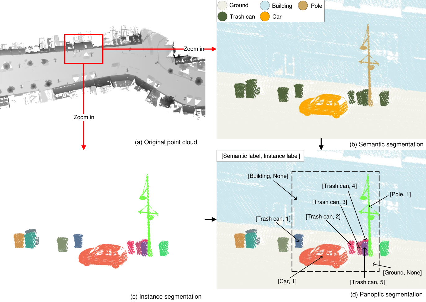
As shown in Figure 2, panoptic segmentation is nowadays usually formulated as a combined classification and clustering task and solved with deep neural networks. The general architecture is to first extract a per-point feature encoding with a backbone network, then feed the encoding into two parallel branches (heads), one that predicts semantic class probabilities and another one that further transforms the points such that points on the same instance form compact clusters, achieving both task simultaneously based on shared features. Historically, instance segmentation has been developed in 2D image analysis, as an add-on to semantic segmentation. Consequently, the focus has been on the design of the instance branch, without questioning the backbone. No systematic studies exist that investigate how different 3D backbones support point cloud instance segmentation. Moreover, panoptic segmentation of outdoor scenes has almost exclusively been studied for sparse, sequential scan data from autonomous driving scenarios like SemanticKITTI (behley2019iccv; behley2021ijrr) or nuScenes (nuscenes2019; fong2021panoptic), often in a real-time sceneario. It appears that panoptic segmentation of dense, mapping-grade point clouds has not been investigated much.
There are a number of review papers about deep learning for 3D point clouds. Some review papers attempt a comprehensive overview of different point cloud analysis tasks (Ioannidou2017DeepLA; Liu2019Deep; Bello2020review; Deep2020Li; Lu2020Deep; Guo2020Deep), predominantly scene-level classification, segmentation, and object detection. Others concentrate on a single analysis task (Griffiths2019Areview; Wu2021Deep; He2021Deep; Zamanakos2021Comprehensive; zhao2021technical; Burume2021Deep; Jhaldiyal2022Semantic; Diab2022Deep; Alaba2022ASurvey). For example, several papers review 3D object detection methods for autonomous driving (Wu2021Deep; Zamanakos2021Comprehensive; Alaba2022ASurvey), and Burume2021Deep focus on instance segmentation in that scenario. zhao2021technical did a survey to explore the effects of different traditional point cloud clustering algorithms for LiDAR panoptic segmentation task. To date, there has not been a review that specifically addresses the panoptic segmentation task for dense, mapping-grade 3D LiDAR point clouds. The present work aims to fill that gap. Besides systematically introducing the task and discussing important representative works, it also provides a unified experimental test bed and comparative results for reference.
Following the literature about deep learning for point clouds (Griffiths2019Areview; Deep2020Li; Wu2021Deep; He2021Deep; Zamanakos2021Comprehensive; Diab2022Deep; Alaba2022ASurvey), 3D backbone networks are classified into four classes: voxel-based, point-based, 2D projection-based, and other presentations, which will be discussed in Section 2. For the further investigation of dense outdoor point cloud panoptic segmentation, the paper focuses on three representative backbone networks: PointNet++ (Qi2017PointNetDH), Sparse CNN (choy20194d), and KPConv (Thomas2019KPConvFA). The choice is motivated by the following considerations. First, PointNet++ and Sparse CNN are currently the most widely used point cloud backbones (see Table ). Second, KPConv and Sparse CNN are particularly successful backbones for segmentation tasks, with KPConv achieving state-of-the-art performance for semantic segmentation on the NPM3D dataset (roynard2017parislille3d), while Sparse CNN is the most widely used backbone for state-of-the-art instance segmentation of indoor point clouds (jiang2020pointgroup; chen2021hierarchical; Vu2022SoftGroup). The three types of backbones are described in detail in Section 2.
Section of the paper distinguishes top-down and bottom-up strategies, like other articles about 3D point cloud instance segmentation (He2021Deep; Burume2021Deep). Additionally, the present paper introduces and summarizes the two most commonly used strategies for bottom-up methods (Table and Section ), and compares their performance in the context of outdoor panoptic segmentation (Section ).
So far, there is no outdoor mobile mapping dataset tailored to panoptic segmentation, as existing datasets lack instance labels. Existing outdoor datasets of LiDAR point clouds with instance labels are dominated by the autonomous driving setting. I.e., the points are comparatively sparse, moreover instance labels are typically limited to pedestrians and vehicles (see Section ), whereas for mapping a wider variety of object classes should be instantiated, such as trees, poles, street lamps and so on. For the present work, this meant on the one hand that a new dataset had to be generated, which we do by adding instance labels to an existing benchmark, see Section ). On the other hand, the lack of a common dataset also meant that for the review it was not possible to collect the results of different methods from the literature. Instead, a common code base for different methods was implemented and applied on the new dataset to enable informative and fair comparisons.
In summary, the main contributions of the present paper are:
- 1.
A detailed literature review about 3D point cloud panoptic segmentation, grouped into four sub-topics: datasets, 3D backbone networks for semantic segmentation, strategies for instance segmentation, and evaluation metrics. See also Figure 2.
- 2.
An experimental evaluation and comparison in the outdoor mobile mapping setting. The evaluation concentrates on the bottom-up segmentation and grouping strategy (see Section ), which so far proved to be the most successful approach and dominates the leaderboards for indoor datasets. To that end, a modular panoptic segmentation pipeline (Section ) was created that allows one to combine different feature extraction and segmentation strategies. Extensive experiments are run on the NPM3D dataset (roynard2017parislille3d) with three different, representative backbones and two representative instance clustering approaches (Section ).
- 3.
The instance-annotated dataset and all source code will be published, so as to expedite further research and promote the development of 3D panoptic segmentation. So far, there do not seem to be any other works that systematically investigate modern deep learning methods for panoptic segmentation of mobile mapping point clouds.
2 Backbone networks for 3D point cloud analysis
Traditionally, 3D point cloud analysis has relied on manually designed features that capture the local point distribution (and thus, the surface shape) around a point (niemeyer2012conditional; Li2016ATA; Zhu2017RobustPC). This works well for categories with sufficiently obvious, distinctive features, but much time and effort are required to design features, select appropriate neighborhoods, etc. Such approaches no longer reach state-of-the-art performance, mostly because it is not clear how to manually design a good representation of contextual relations over larger contexts. Furthermore, the handcrafted features tuned for a point cloud with specific sensing characteristics typically fail to handle other types of scenes or other sensor settings, meaning that the tedious manual feature engineering must be repeated.
At present, deep learning is the standard technology to automatically extract discriminative, robust feature representations from raw data. Remarkable results have been achieved for 2D image classification, semantic segmentation, object detection, and more (lecun2015deep). Motivated by those results and a growing number of public 3D point cloud datasets, researchers have developed powerful deep learning algorithms to also extract features for 3D point cloud analysis (Ioannidou2017DeepLA). These existing 3D “backbone” networks can be grouped into three main schools, namely voxel-based networks, 2D projection-based networks, and point-based networks. Representative examples are summarized in Table 2.5.
2.1 Voxel-based networks
The points in a point cloud are generally unstructured and have irregular density. These characteristics are quite different from images, where relationships between pixels can be captured with regular, discrete convolution kernels. The simplest and most direct strategy to apply deep learning to 3D point clouds is to voxelise the underlying point data and use 3D Convolutional Neural Networks (CNNs) (Maturana2015VoxNetA3) (Figure 3(a) and Figure 4(a)). Perhaps the first attempt to use CNNs for semantic segmentation of outdoor point clouds was Huang2016Point. However, when moving to a voxel representation the computational cost and, more importantly, the memory demand increases cubically with the resolution, thus limiting the practical usability of 3D CNNs (Riegler2017OctNetLD). To bring down the memory requirements, hierarchical and/or sparse voxel representations have been developed. Hierarchical volumetric models (Riegler2017OctNetLD; Wang2017OCNNOC) use data structures like octrees to focus memory allocation and computation on the relevant regions where there are points (Figure 3(b) and Figure 4(b)). The same principle, to omit the vast amount of empty 3D space, is also the basis of methods that employ sparse tensors (Graham20183DSemantic; choy20194d; tang2020searching) and associated functions that only perform calculations for non-empty voxels (Figure 3(c) and Figure 4(c)). The Minkowski Engine (choy20194d) and the SparseConvNet library (Graham20183DSemantic) are two popular software frameworks that support all standard neural network layers like convolution, pooling and upsampling, for sparse tensors. Figures 3 and 4 illustrate how dense voxel grids, octrees and sparse tensors, respectively, store point clouds and compute convolutions.

2.2 2D projection-based networks
To avoid the complications of a 3D voxel space, another strategy are 2D projection-based methods. Their basic idea is to convert the original 3D point cloud into a regular 2D raster, which can then be treated with standard 2D CNNs. Variants include single- or multi-view perspective projections (Lawin2017DeepP3; Kalogerakis20173DSS), parallel (Tatarchenko2018TangentCF) as well as spherical projections (wu2018squeezeseg; wu2019squeezesegv2). This type of approach tends to work well when the underlying assumptions are met, e.g., well-behaved surfaces with an unambiguous normal/tangent (Tatarchenko2018TangentCF) or individual scans (respectively, range images) that, in actual fact, induce a 2D parametrisation.
2.3 Point-based networks
To side-step the representation change altogether, point-based networks directly work on irregular point clouds (Qi2017PointNetDL; Qi2017PointNetDH; hua2018pointwise; wang2019graph; Wang2019DynamicGC; Thomas2019KPConvFA). The earliest such method was PointNet (Qi2017PointNetDL), where a per-point multiple-layer perceptron (MLP) is combined with max-pooling to achieve a global feature invariant to permutations of the points (Figure 5(a)). PointNet++ (Qi2017PointNetDH) builds upon PointNet and adds a step-wise hierarchical aggregation to retain more of the spatial layout (Figure 5(b)). A different method, more in the spirit of CNNs, is the kernel point convolution (Thomas2019KPConvFA, KPConv,), which approximates the 3D convolution in continuous space by interpolation and also hierarchically aggregates multi-scale features to capture both local and global information (Figure 5(c)). It has shown excellent performance on outdoor data, like NPM3D (roynard2017parislille3d) and Semantic3D (hackel2017isprs).

2.4 Other representations
Besides the three main groups described so far, there have been a few other attempts to process 3D data with reasonable memory footprint. These include permutohedral lattices (su2018splatnet; rosu2019latticenet), offline grouping into irregular patches, combined with graph convolutional networks (landrieu2018large), and hybrid models (dai20183dmv; jaritz2019multi).
2.5 Semantic segmentation of point clouds
Semantic segmentation assigns each point to a semantic class, without distinguishing different instances within the class. This is accomplished by adding a segmentation “head” to the backbone, which outputs a class distribution for each individual point. Overall, this results in an encoder-decoder structure: the backbone encodes the input into a latent representation optimised for classification, and the classification head decodes that representation into class scores. For voxel-based, projection-based and sparse tensor-based methods, the decoder consists of a sequence of transposed convolutions. For PointNet-style methods, the per-point features and the latent representation over a larger spatial context are simply concatenated and decoded with an MLP.
| Summary of different types of representative backbone networks for 3D point clouds. | ||||
| Representatives | Methodology | Advantages | Disadvantages |