- 5G
- fifth-generation
- ADAS
- advanced driver assistance systems
- API
- application programming interface
- AWGN
- additive white Gaussian noise
- BEP
- beacon error probability
- BP
- beacon periodicity
- BR
- beacon resource
- BSM
- basic safety message
- BSS
- basic service set
- C-ITS
- cooperative intelligent transport systems
- C-V2X
- cellular-vehicle-to-anything
- CA
- cooperative awareness
- CAM
- cooperative awareness message
- CAM-R
- CAM (CAM) resource
- CAV
- connected and autonomous vehicle
- CCA
- clear channel assessment
- CCDF
- complementary cumulative distribution function
- CD
- collision detection
- CDF
- cumulative distribution function
- c.f.
- characteristic function
- CSI
- channel state information
- CSMA/CA
- carrier sense multiple access with collision avoidance
- D2D
- device-to-device
- DSRC
- dedicated short range communication
- ERP
- equivalent radiated power
- FCD
- floating car data
- FD
- full duplex
- FDD
- frequency division duplex
- GPS
- global positioning system
- HD
- half duplex
- HIL
- hardware-in-the-loop
- ICRW
- intersection collision risk warning
- ICWS
- intersection collision warning system
- ITS
- intelligent transport system
- ITS-S
- intelligent transport system station
- i.i.d.
- independent identically distributed
- JDBC
- Java database connectivity
- LOS
- line of sight
- LTE
- long term evolution
- LTE-D2D
- LTE (LTE) with device-to-device communications
- LTE-V2V
- LTE-vehicle-to-vehicle
- LTE-V2X
- LTE-vehicle-to-anything
- MAC
- medium access control
- MCS
- modulation and coding scheme
- MD
- allocation with maximum reuse distance
- NHTSA
- National Highway Traffic Safety Administration
- NLOS
- non line of sight
- OBC
- on-board computer
- OBU
- on-board unit
- OCB
- outside the context of a BSS
- OFDM
- orthogonal frequency division multiplexing
- probability density function
- PEP
- pairwise error probability
- PER
- packet error rate
- PHY
- physical
- PMF
- probability mass function
- PPP
- Poisson point process
- ProSe
- proximity services
- PRP
- packet reception probability
- QoS
- quality of service
- r.v.
- random variable
- RF
- radio frequency
- RB
- resource block
- RR
- random resource allocation
- RSU
- road-side unit
- SC-FDMA
- single carrier-frequency division multiple access
- SHINE
- simulation platform for heterogeneous interworking networks
- SI
- self-interference
- SINR
- signal to noise and interference ratio
- SNR
- signal to noise ratio
- SPS
- semi-persistent scheduling
- SUMO
- simulation of urban mobility
- TraaS
- TraCI as a Service
- TraCI
- traffic control interface
- TRUDI
- testing environment for vehicular applications running with devices in the loop
- SV
- smart vehicle
- TDD
- time division duplex
- TraCI
- traffic control interface
- V2C
- vehicle-to-cellular
- V2I
- vehicle-to-infrastructure
- V2R
- vehicle-to-roadside
- V2V
- vehicle-to-vehicle
- V2X
- vehicle-to-anything
- VANETs
- vehicular ad hoc networks
- SDR
- Software Defined Radio
A Hardware-in-the-Loop Evaluation of the Impact of the V2X Channel on the Traffic-Safety Versus Efficiency Trade-offs
Abstract
11 1 ©2020 IEEE. Personal use of this material is permitted. Permission from IEEE must be obtained for all other uses, in any current or future media, including reprinting/republishing this material for advertising or promotional purposes, creating new collective works, for resale or redistribution to servers or lists, or reuse of any copyrighted component of this work in other works.Accepted version, to be presented at EuCAP 2020.
Vehicles are increasingly becoming connected and short-range wireless communications promise to introduce a radical change in the drivers’ behaviors. Among the main use cases, the intersection management is surely one of those that could mostly impact on both traffic safety and efficiency. In this work, we consider an intersection collision warning application and exploit an hardware-in-the-loop (HIL) platform to verify the impact on the risk of accidents as well as the average time to travel a given distance. Besides including real ITS-G5 compliant message exchanges, the platform also includes a channel emulator with real signals. Results show that the risk of collisions can be drastically reduced, with an overall trade-off between safety and traffic efficiency. At the same time, it is shown that the presence of real channel conditions cannot guarantee the same condition of zero-risk as with ideal channel propagation, remarking the importance of channel conditions and signal processing.
Index Terms:
V2X; ITS-G5; channel emulation; hardware-in-the-loop simulation; intersection collision risk warning.I Introduction
All future vehicles are expected to be equipped with wireless technologies enabling to share real time information and concurrently improve safety, optimize traffic, and provide novel services to the passengers. Probably, the process will ultimately lead to vehicles that will mostly be autonomous and connected to each other. A major step in this direction, which has long been promised, although it has not happened yet, is the full connectivity among vehicles through the use of short-range wireless communications. While various technologies are being considered and validated, including those around IEEE 802.11p and those in the area of cellular systems [1], still more investigations to quantify the impact of such systems on real large-scale scenarios are being carried out.
Among the various use cases where short-range communications are expected to play a crucial role, there is what ETSI calls ICRW (ICRW) [2]. The prevention of accidents at intersections is in fact of utmost importance towards vision zero, as demonstrated by several studies (for example, they accounted for more than 20% of crashes in Europe in [3] and for about 40% in the US in [4]).
This work focuses on the impact of an ICRW implementation, assuming vehicles connected using ITS-G5, which is the European technology based on IEEE 802.11p [5]. Particular emphasis will be given on the one hand on the trade-off between the granted safety level and the deriving traffic efficiency, and on the other hand on the impact of a realistic signal propagation.
To this aim, we have developed an HIL (HIL) simulation platform that includes both ITS-G5 devices and a channel emulator. Differently from most of studies, which are based on simulators such as VEINS [6] or iTETRIS [7] and unavoidably approximate the physical layer, in this study the signal propagation and thus the effectiveness of communications is assessed through ITS-G5 transceivers and a channel emulator. Interestingly, the platform is implemented through a multi-laboratory approach, with a core part based on the traffic simulator SUMO [8] and the TRUDI (TRUDI) [9], running in Bologna, Italy, and the signal generation and channel emulation running in Vienna, Austria.
As a reference scenario we have considered an urban area of the city of Bologna, and the performance has been evaluated in terms of both the occurred collisions (network performance) and the average travel time (efficiency of the application). The results with the implemented ICRW application and the emulated channels are then compared with ideal reference conditions, remarking that the assumption of ideal channel conditions is not suitable to assess the real impact of vehicular applications.
II Use Case Definition
This study considers connected, human driven, vehicles in an urban area with moderate traffic. Each vehicle is equipped with an ICRW application helping the driver to be aware of approaching vehicles with the right of way. The aim is to focus on what would be possible today if all vehicles were equipped with the ITS-G5 technology and ICRW was implemented.
II-A Intersection collision warning application
The implemented ICRW is summarized in Algorithm 1. It applies to those vehicles that are approaching an intersection and do not have the right of way. Specifically, the application calculates the level of risk, based on the real time information exchanged through the so-called CAM, which are periodic messages transmitted via ITS-G5. If necessary, it warns the driver of a dangerous situation. Although here we assume cars driven by humans, the algorithm could be easily adapted to partially or fully automated vehicles.
The level of risk is evaluated by calculating the absolute difference between the time, , necessary to the vehicle to reach the intersection and the time, , necessary to the first of the vehicles approaching from the other roads to reach the same intersection and comparing it with some given thresholds.
More specifically, two thresholds denoted as warning threshold and alarm threshold are assumed. The variable to be compared is obtained as , where , stays for either or , is the distance between the vehicle and the intersection, and is the speed of .
If is below and above , then the application sends a warning message to the driver. If is below , then it also sends a warning message if the time is sufficient for a safe and comfort break, otherwise it generates an alarm to request a sudden action by the driver.
A field trial example of an early version of the application, not including the risk levels, was presented in [9].
II-B Channel models
The channel models combine pathloss and small-scale fading. The pathloss is given by
| (1) |
with dB and the pathloss exponent , similar to [10]. On top of this pathloss, we model small-scale fading according to a stationary tapped-delay line model
| (2) |
Here, is the relative path power in dB, is the relative path delay of the th tap, and is a stationary fading trace. We use the channel model parameters for urban LOS (LOS) and NLOS (NLOS) as shown Tab. I and defined in [11]. The models use taps, and assume the first tap to be completely static. The other taps are all Rayleigh distributed, and use half-bathtub spectra (HalfBT). indicates the maximum Doppler spread, while the sign shows whether the left of right side is nonzero.
| Name | Tap | [dB] | [ns] | [Hz] | Profile |
|---|---|---|---|---|---|
| Urban LOS | Static | ||||
| 236 | HalfBT | ||||
| HalfBT | |||||
| HalfBT | |||||
| Urban NLOS | Static | ||||
| HalfBT | |||||
| HalfBT | |||||
| HalfBT |
II-C Output metrics
The following two output metrics are used, one dealing with safety and the other with traffic efficiency. For both of them, the reference situation is when all drivers are careful and respect the rights of way, in that case no collision occurs.
II-C1 Average collisions per hour
It indicates the number of collisions between two vehicles that have occurred during the simulations, averaged over 1 hour. This metric highlights the effectiveness of the ICRW to improve safety at intersections.
II-C2 Time improvement to careful case
Considering the time needed to travel a reference distance (e.g., 1 km), it is defined as the time difference between the time spent by the vehicle to travel the distance and the time that the vehicle would spend if all drivers were always careful and diligently respected the rights of way. This metric quantifies the improvement in traffic efficiency and a negative value means that more time is (on average) required to cover the same distance.
III The Hardware-in-the-Loop Platform
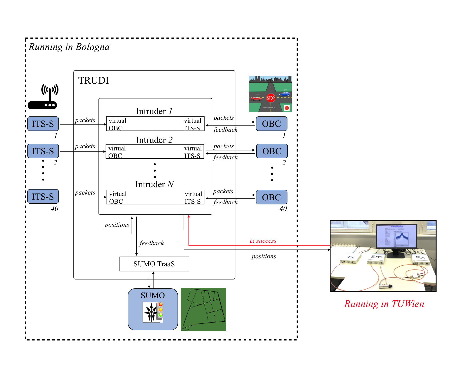
The HIL platform consists of two main parts, one based on the HIL platform TRUDI [9] and the traffic simulator SUMO [8], running in Bologna, and the other focusing on signal generations and channel emulation, running in Vienna. A block scheme of the platform is shown in Fig. 1. All simulations run in real time, with a one-to-one correspondence between simulated and simulation time.
III-A TRUDI
The TRUDI platform, detailed in [9], is based on the so-called intruders, which act between the wireless devices (or ITS-S) and the corresponding controllers running inside the cars (or OBC). Each intruder mimics the OBC for the ITS-S and the ITS-S for the OBC, thus receiving and passing all exchanged messages, with the possibility to alter the content and simulate some events. In particular, the intruders modify the GPS coordinates received from the ITS-S with those obtained from the traffic simulator SUMO in order to reproduce the mobility on the road. In addition, it discards some of the messages to reproduce the transmission errors due to channel impairments.
At the same time, TRUDI receives from the OBCs a feedback indicating warnings or alarms from the ICRW application, which are then used to modify the drivers’ behavior in the traffic simulator.
III-B SUMO and the behavior of drivers
SUMO [8] is an open source microscopic and continuous traffic simulator. Among the several features of SUMO, it is also possible to modify the behavior of the drivers, for example making them more aggressive. In order to investigate the impact of the ICRW application, in this work we have exploited a feature of SUMO that allows to set the drivers to either respect or not the right of way at intersections.
First of all, we consider the following benchmark.
- •
Careful case: all drivers are always careful and respect the correct rights; this case corresponds to the basic operation of SUMO.
Figures will not explicitly show results regarding this case. In fact, looking at safety it implies no collisions by design and, focusing on traffic efficiency, the adopted metric is obtained as an improvement compared to this case.
As a further reference, we also evaluate the following case.
- •
No-App case: all drivers are always distracted (i.e., they do not respect the right of way).
All other cases imply the exploitation of wireless communications and the implemented application, as hereafter detailed.
- •
ICRW cases: all drivers are normally distracted, but become careful when alerted by the application; more specifically, if the ICRW warning is activated, then the driver becomes careful with i.i.d. probability 0.5; if the ICRW alarm is triggered, then the driver becomes careful with probability 1 (i.e., they always become careful); the driver is again distracted once the vehicle crosses the intersection.
Please note that, for the sake of readability, the acronym ICRW is left implicit in the figures of Section IV and all results except for the No-App belong to these cases.
III-C Channel emulation
The testbed for emulation consists of two SDR (SDR) platforms, namely, two NI USRP-2953R modules each equipped with 40 MHz of operation and two RF channels. One USRP is running the NI 802.11 project code which was modified to support 802.11p stack. The SDR is set up in RF loop-back configuration, with channel 0 acting as transmitter, and channel 1 acting as the receiver. The other USRP module programmed as channel emulator is placed between the transmitter and the receiver. The SDR implements the time-variant channel emulator described in [12] and replicates the channel described in Tab. I.
At each periodic generation of the CAM, a vector with the position of all the vehicles in the scenario is sent from TRUDI to the channel emulator. Based on this information, the first device logs transmission successes and failures at the receiving side, and records these events. A matrix with a map of correctly received and lost messages is returned to TRUDI. Currently, a limited number of vehicles is considered, thus interference and collisions are assumed negligible.
IV Results
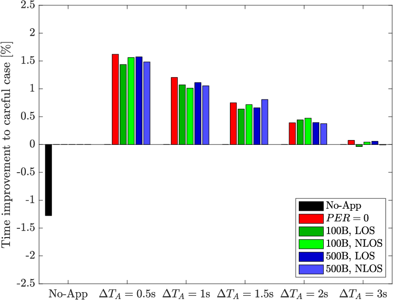
Results obtained in the scenario are exemplified in Fig. 2. It corresponds to a portion of the city of Bologna derived from OpenStreetMap ([13]) in the premises of the Engineering School of the University of Bologna. Each simulation consists of 10 hours with 40 vehicles moving with random directions and a maximum speed of 50 km/h. The main settings are also summarized in Table II. Two groups of results, assuming either ideal or realistic channel conditions, are shown in Figs. 3 and 4, respectively. The two metrics detailed in Section II-C are shown varying the alarm threshold . The warning threshold is always set to and left implicit in the following.

| Scenario | |
| Simulated time | 10 hours |
| Number of vehicles | 40 |
| Maximum speed of vehicles | 50 km/h |
| Algorithm | |
| Warning time threshold | |
| Alarm time threshold | Variable |
| Deceleration (for the time to break ) | 4 |
| Reaction time | 1 s |
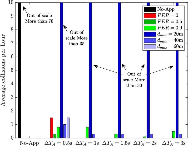
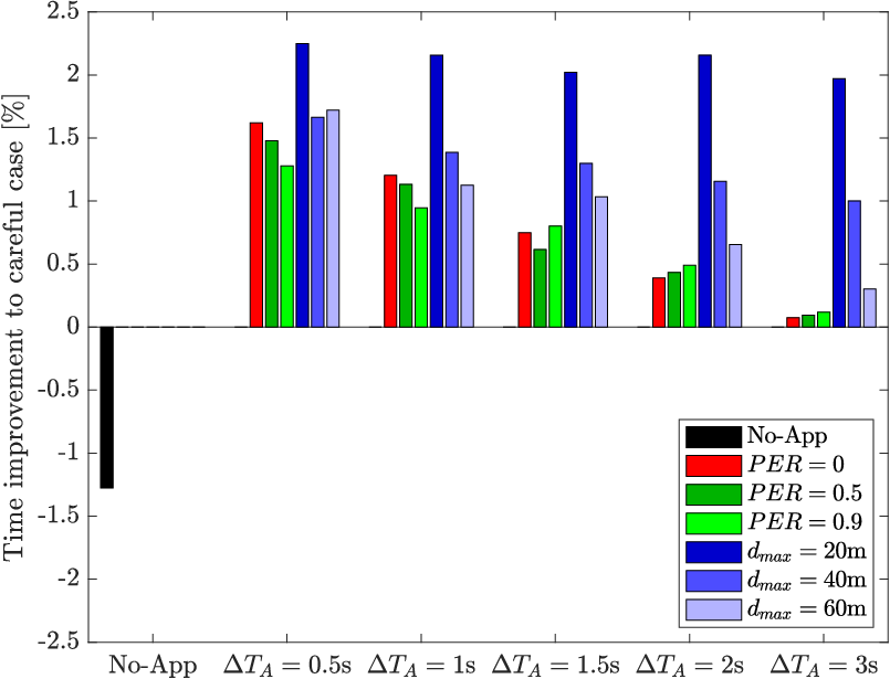
Fig. 3 compares the No-App case (see Section III-B) with the ICRW cases, assuming ideal channels. Specifically, the following channels are considered:
- 1.
: all packets are lost with i.i.d. probability , independently to the position of the vehicles;
- 2.
m: all packets exchanged between vehicles whose distance is less than m are correctly received, otherwise they are lost.
It can be noted from Fig. 3(a) that a lower number of collisions is always granted by the application. The reduction is more or less halved if the coverage is limited to 20 m ( m) and drastically reduced in all the other cases. It can also be observed that a value of s is insufficient to avoid all the collisions, neither with an ideal channel, whereas a value of s allows to have no accidents when the error rate is kept at 50 or the range sufficiently large ( m).
Looking at Fig. 3(b), a positive impact on the travel time can also be noted, except for the No-App case. This means that the vehicles reduce their speed only when strictly needed, improving the traffic efficiency. As expected, the time improvement reduces with an increase of , making clear the trade-off between traffic safety and efficiency. It is worth noting that the shown improvement, which might appear small, is obtained considering the entire route of the vehicles, even if the application is effective only near the intersections.
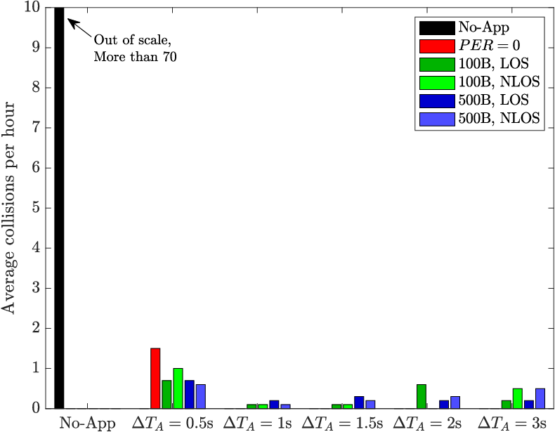
Fig. 4 shows the same outputs when the realistic channels detailed in Section II-B are used. Again, a drastic reduction of accidents (Fig. 4(a)) and an improvement of traffic efficiency (Fig. 4(b)) can be observed, with a trade-off between them that depends on the chosen value of .
One important aspect to remark comparing Figs. 3 and 4 is that with realistic channel conditions the number of collisions occurred in a simulation never goes to zero, neither fixing s and basically there is no advantage in terms of traffic efficiency. This is due to the fact that in a real scenario errors tend to be strongly correlated, and bursts of errors occur, causing the presence of periods of unawareness even when the average error rate is limited.
V Conclusion
In this work, we have considered an ICRW application used in an urban scenario to improve safety and traffic efficiency, with the aim to investigate the impact of a realistic channel. The objective has been achieved exploiting a HIL platform where real ITS-G5 signals are exchanged through a channel emulator configured with realistic channels. Results have indeed demonstrated a certain trade-off between traffic safety and efficiency. In addition, the impact of realistic channels causes residual accidents in all situations, which were not observed for ideal channel conditions.
Acknowledgment
This work has been partially conducted within the DARVIS project funded by the Austrian Aeronautics Research and Technology Program TAKEOFF under grant agreement No 867400.
References
- [1] A. Bazzi, G. Cecchini, M. Menarini, B. M. Masini, and A. Zanella, “Survey and perspectives of vehicular Wi-Fi versus sidelink cellular-V2X in the 5G era,” Future Internet, vol. 11, no. 6, p. 122, 2019.
- [2] “Intelligent transport systems (ITS); V2X applications; part 2: Intersection collision risk warning (ICRW) application requirements specification,” ETSI TS 101.539-2 V1.1.1, 2018.
- [3] “Annual accident report 2018,” European Commission, Tech. Rep., 2018.
- [4] “DOT HS 811 366 crash factors in intersection-related crashes: An on-scene perspective,” NHTSA, Tech. Rep., 2010.
- [5] E. G. Ström, “On medium access and physical layer standards for cooperative intelligent transport systems in europe,” Proceedings of the IEEE, vol. 99, no. 7, pp. 1183–1188, July 2011.
- [6] C. Sommer, R. German, and F. Dressler, “Bidirectionally coupled network and road traffic simulation for improved IVC analysis,” IEEE Transactions on Mobile Computing, vol. 10, no. 1, pp. 3–15, 2011.
- [7] V. Kumar, L. Lin, D. Krajzewicz, F. Hrizi, O. Martinez, J. Gozalvez, and R. Bauza, “iTETRIS: adaptation of its technologies for large scale integrated simulation,” in 2010 IEEE 71st Vehicular Technology Conference, 2010, pp. 1–5.
- [8] D. Krajzewicz, J. Erdmann, M. Behrisch, and L. Bieker, “Recent development and applications of SUMO - Simulation of Urban MObility,” International Journal On Advances in Systems and Measurements, vol. 5, no. 3&4, pp. 128–138, December 2012.
- [9] M. Menarini, P. Marrancone, G. Cecchini, A. Bazzi, B. M. Masini, and A. Zanella, “TRUDI: Testing environment for vehicular applications running with devices in the loop,” in IEEE ICCVE, 2019.
- [10] A. Bazzi, B. M. Masini, A. Zanella, and I. Thibault, “On the performance of IEEE 802.11p and LTE-V2V for the cooperative awareness of connected vehicles,” IEEE Transactions on Vehicular Technology, vol. PP, no. 99, pp. 1–1, 2017.
- [11] T. Blazek, M. Ashury, C. F. Mecklenbräuker, D. Smely, and G. Ghiaasi, “Vehicular channel models: A system level performance analysis of tapped delay line models,” in 2017 15th International Conference on ITS Telecommunications (ITST). IEEE, 2017, pp. 1–8.
- [12] G. Ghiaasi, T. Blazek, M. Ashury, R. R. Santos, and C. Mecklenbräuker, “Real-time emulation of nonstationary channels in safety-relevant vehicular scenarios,” Wireless Communications and Mobile Computing, vol. 2018, no. 2423837, pp. 1–11, 2018.
- [13] “OpenStreetMap.” [Online]. Available: https://www.openstreetmap.org